1904 USGS Topographic Map of Crandall, Yellowstone National Park 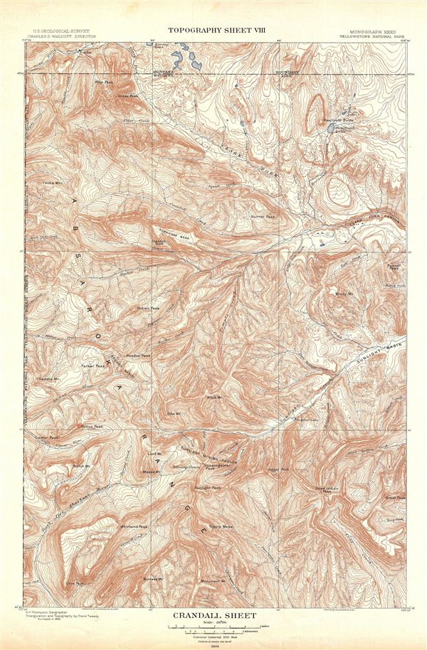 WE SELL ONLY ORIGINAL ANTIQUE MAPS - NOT REPRODUCTIONS Title: Crandall Sheet. Topography Sheet VIII. Description: A fine example of Arnold Hagues 1904 topographical survey map of the spectacular Crandall Region in the Yellowstone National Park, Wyoming. Centered on Crandall Creek, the map covers the Absaroka Range from the Crow Peak to Kersey Lake in Montana. The map identifies various creeks, mountains, peaks other sites of interest throughout. The boundary line between Montana and Wyoming runs along the breath of the map on the top. This particular map was part of Hagues study of the regions unique geology and the related geothermal activity. Published by the United States Geological Survey in 1904. Size: Printed area measures 21 inches high by 14 inches wide. Condition: Very good. Blank on verso. Shipping: Shipping rates are not negotiable. Items are shipped within three business days of receiving payment. We are happy to consolidate shipping where possible. The following shipping options are available: 1. FedEx Overnight (45 USD). USA Only. Signature Required. Customs: International buyers are responsible for paying duty and taxes on delivery. DHL or FedEx will contact the buyer by telephone to arrange tax payment if it is levied. Duty varies by country and we cannot predict the amount you will be charged. Some countries are duty free, others are not. Typically, a customs duty and/or VAT tax will be assessed on all parcels to continental Europe. Sometimes duty or tax is due in China, but is seems very random. Hong Kong, Singapore, Korea, and Taiwan have never assessed duty on a map we shipped. Maps shipped to the UK should be duty free as educational materials, but from time to time duty of 5% is assessed incorrectly by the UK customs agents. Insurance: All shipments are insured privately against loss and damage. All of our shipments require a signature for insurance purposes. If you have any questions please feel free to email us through eBay. Other Services Conservation Framing: Geographicus recommends basic conservation framing services for any antique paper. We do not offer this service. |

" class="zoomMainImage swiper-slide">
1904 USGS Topographic Map of Crandall, Yellowstone National Park WE SELL ONLY ORIGINAL ANTIQUE MAPS - NOT REPRODUCTIONS Title: Crandall Sheet. Topography Sheet VIII. Description: A fine example of Arnold Hagues 1904 topographical survey map of the spectacular Crandall Region in the Yellowstone National Park, Wyoming. Centered on Crandall Creek, the map covers the Absaroka Range from the Crow Peak to Kersey Lake in Montana. The map identifies various creeks, mountains, peaks other sites of interest throughout. The boundary line between Montana and Wyoming runs along the breath of the map on the top. This particular map was part of Hagues study of the regions unique geology and the related geothermal activity. Published by the United States Geological Survey in 1904. Size: Printed area measures 21 inches high by 14 inches wide. Condition: Very good. Blank on verso. Shipping: Shipping rates are not negotiable. Items are shipped within three business days of receiving payment. We are happy to consolidate shipping where possible. The following shipping options are available: 1. FedEx Overnight (45 USD). USA Only. Signature Required. Customs: International buyers are responsible for paying duty and taxes on delivery. DHL or FedEx will contact the buyer by telephone to arrange tax payment if it is levied. Duty varies by country and we cannot predict the amount you will be charged. Some countries are duty free, others are not. Typically, a customs duty and/or VAT tax will be assessed on all parcels to continental Europe. Sometimes duty or tax is due in China, but is seems very random. Hong Kong, Singapore, Korea, and Taiwan have never assessed duty on a map we shipped. Maps shipped to the UK should be duty free as educational materials, but from time to time duty of 5% is assessed incorrectly by the UK customs agents. Insurance: All shipments are insured privately against loss and damage. All of our shipments require a signature for insurance purposes. If you have any questions please feel free to email us through eBay. Other Services Conservation Framing: Geographicus recommends basic conservation framing services for any antique paper. We do not offer this service. |
" alt="1904 USGS Topographic Map of Crandall, Yellowstone ventes exceptionnelles National Park" width="527" height="527" />

1904 USGS Topographic Map of Crandall, Yellowstone ventes exceptionnelles National Park
1904 USGS Topographic Map of Crandall, Yellowstone ventes exceptionnelles National Park, 1904 USGS Topographic Map of Crandall, Yellowstone National Park collections
€246.35
SKU: 8196270
Colour
"
1904 USGS Topographic Map of Crandall, Yellowstone National Park
WE SELL ONLY ORIGINAL ANTIQUE MAPS - NOT REPRODUCTIONS
Title: Crandall Sheet. Topography Sheet VIII.
Description: A fine example of Arnold Hagues 1904 topographical survey map of the spectacular Crandall Region in the Yellowstone National Park, Wyoming. Centered on Crandall Creek, the map covers the Absaroka Range from the Crow Peak to Kersey Lake in Montana. The map identifies various creeks, mountains, peaks other sites of interest throughout. The boundary line between Montana and Wyoming runs along the breath of the map on the top. This particular map was part of Hagues study of the regions unique geology and the related geothermal activity. Published by the United States Geological Survey in 1904.
Size: Printed area measures 21 inches high by 14 inches wide.
Condition: Very good. Blank on verso.
Shipping: Shipping rates are not negotiable. Items are shipped within three business days of receiving payment. We are happy to consolidate shipping where possible. The following shipping options are available:1. FedEx Overnight (45 USD). USA Only. Signature Required.
2. FedEx Ground or Home Delivery (15 USD). USA Only. 1 - 10 days. If your address is a P.O. Box and cannot ship FedEx we will ship USPS Priority and, while we ship promptly, recent postal personnel cutbacks mean that delivery may take time. Signature Required.
3. FedEx International or DHL International EXPRESS (45 USD).
4. We can use your FedEx Account.
Customs: International buyers are responsible for paying duty and taxes on delivery. DHL or FedEx will contact the buyer by telephone to arrange tax payment if it is levied. Duty varies by country and we cannot predict the amount you will be charged. Some countries are duty free, others are not. Typically, a customs duty and/or VAT tax will be assessed on all parcels to continental Europe. Sometimes duty or tax is due in China, but is seems very random. Hong Kong, Singapore, Korea, and Taiwan have never assessed duty on a map we shipped. Maps shipped to the UK should be duty free as educational materials, but from time to time duty of 5% is assessed incorrectly by the UK customs agents.
Insurance: All shipments are insured privately against loss and damage. All of our shipments require a signature for insurance purposes.
If you have any questions please feel free to email us through eBay.
Other ServicesConservation Framing: Geographicus recommends basic conservation framing services for any antique paper. We do not offer this service.
Antique Map Restoration: Geographicus can repair and restore your antique map. Services include deacidification cleaning flattening and backing.
BEWARE anyone attempting to contact you, from a different eBay account, claiming to represent Geographicus Antique Maps. My eBay handle is GeographicusMaps. If you are contacted by email by someone offering you my items, please call me directly to be certain you are not dealing with a con artist." alt="1904 USGS Topographic Map of Crandall, Yellowstone ventes exceptionnelles National Park" width="52" height="52" >
Personalised:: ( x )Personalisation:EditRemove PersonalisationAvailable From:
Buy now.
Pay later.
Earn rewards
Representative APR: 29.9% (variable)
Credit subject to status. Terms apply.
Missed payments may affect your credit score
FrasersPlus
Available Products
SIMILAR ITEMS
- 1904 USGS Topographic Map of Crandall, Yellowstone National Park
- Tarjetero Goyard hombre
- Rob van Tulder New Policy Challenges For European Multinationals (Relié)
- Cardigan tricoté COOGI manches longues tricot 3D taille M fabriqué en Australie
- The North Face Supreme Denim
- Chanel / Portefeuille long
- 【Jupes】ISABEL MARANT 2020 Jupe évasée longueur genou superposée asymétrique fleurie
- Harley Davidson Flhx 1584 Abs 2009-2011 Kit De Printemps Ff Kic 08865-01
- LOUIS VUITTON Serviette Conceier M54422 Noir Epi Cuir Business Bag Homme s Us
- Montre de Poche Vintage Elgin 1937, Grade 315, Modèle 3, 12s, 15j, Fonctionnant à lHeure
Back to top